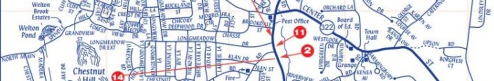


Wolcott, CT Street Map
The most accurate Wolcott town map available online.

The Town of Wolcott, originally known as Farmingbury, was founded in 1796 and is named after Governor Oliver Wolcott, who cast the deciding vote in favor of the Town's incorporation. Wolcott is a residential community with a land area of 21.6 square miles and a population of approximately 16,200. We are located in northern New Haven County, and are a short ride to either Hartford or New Haven.
Wolcott has 5 schools; 3 elementary, 1 middle school and 1 high school. We have a newly constructed Youth Center and Sports Complex. Our other recreational areas include Woodtick Recreational Area, Farmingbury Hills Golf Course and Peterson Park. Wolcott has 5 large bodies of water; most of the lakes/reservoirs are now privately owned by residential communities, but Woodtick Recreational Area is Town-owned and open to the public.
Wolcott also marks the beginning of the Mattatuck Trail, one of Connecticut's finest hiking trails. This 35 mile trail extends in a northwesternly direction from Wolcott to Mohawk Mountain in the Town of Cornwall, where it joins the Appalachian Trail.
Wolcott is home to many types of businesses. We have many small manufacturing-based businesses, 2 large grocery stores as well as restaurants and a variety of small convenience stores.
Visit town website: http://www.wolcottct.org
