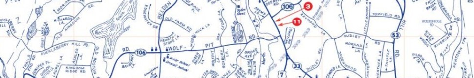


Wilton, CT Street Map
The most accurate Wilton town map available online.

Wilton is nestled in the Norwalk River Valley in western Connecticut. Located in Fairfield County, Wilton is north of the City of Norwalk, west of the Town of Weston, and east of the Town of New Canaan. Wilton's 17,633 residents live in an area of 26.8 sq. miles. Wilton is 55 miles from midtown Manhattan and is within easy driving distance from Westchester County, New York. The Town is accessible from routes 7, 33, 106, and 107. Wilton is only one hour from Grand Central Station on the New Haven Line Danbury branch ofMetro-North Railroad, which runs daily commuter service. In April 1995, Connecticut Magazine named Wilton the top overall town in its size group.
The Town of Wilton was incorporated in 1802, and operates with a Board of Selectmen, Board of Finance and Town Meeting form of government pursuant to the Connecticut Home Rule Act of 1957. The Board of Selectmen is the elected administrative board for the Town. Other elected boards are Finance, Education, Planning and Zoning, ZBA, and Assessment Appeals. Members of these boards are elected by the registered voters and serve as volunteers.
Visit town website: http://www.wiltonct.org
