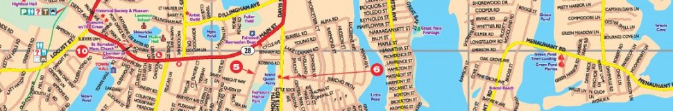


Falmouth, MA Street Map
The most accurate Falmouth town map available online.

Falmouth /ˈfælmɨθ/ is a town in Barnstable County, Massachusetts, United States; Barnstable County is coextensive with Cape Cod. The population was 31,532 at the 2010 census,[2] making Falmouth the second-largest municipality on Cape Cod (behind only Barnstable). The terminal for the Steamship Authority ferries to Martha's Vineyard is located in the village of Woods Hole in Falmouth. Woods Hole also contains several scientific organizations such as the Woods Hole Oceanographic Institution, theMarine Biological Laboratory (MBL), the Woods Hole Research Center, National Marine Fisheries Aquarium, and the scientific institutions' various museums.
Visit town website: http://www.falmouthmass.us
