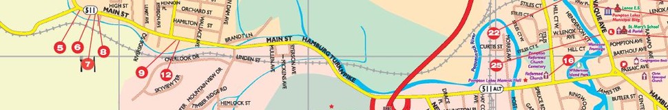


Pompton Lakes / Bloomingdale / Riverdale, NJ Street Map
The most accurate Pompton Lakes / Bloomingdale / Riverdale town map available online.

Pompton Lakes
Pompton Lakes is a 2.97 sq mile suburban community in Passaic County which is home for over 11,900 residents. Three rivers, the Ramapo, Pequannock and Wanaque, run through the Borough providing many relaxing year-round activities for Pompton residents. Pompton's municipal parks, playgrounds and athletic fields host active recreational and competitive sport programs for residents of all ages. Pompton Lakes possesses a pleasant downtown business community which provides a variety of retail stores, service oriented businesses, professional offices and eateries.
Visit town website: http://www.pomptonlakesgov.com/
Bloomingdale
Bloomingdale is a borough in Passaic County, New Jersey, United States. As of the 2010 United States Census, the borough's population was 7,656,[8][9][9] reflecting an increase of 46 (+0.6%) from the 7,610 counted in the 2000 Census, which had in turn increased by 80 (+1.1%) from the 7,530 counted in the 1990 Census.[18]
Visit town website: http://www.bloomingdalenj.net/
Riverdale
Riverdale is a borough in Morris County, New Jersey, United States. As of the 2010 United States Census, the borough's population was 3,559,[7][8][9] reflecting an increase of 1,061 (+42.5%) from the 2,498 counted in the 2000 Census, which had in turn increased by 128 (+5.4%) from the 2,370 counted in the 1990 Census.[18]
Riverdale was incorporated as a borough by an Act of the New Jersey Legislature on March 12, 1923, from portions of Pequannock Township, subject to the results of a referendum passed on April 17, 1923.[19]
Visit town website: http://www.riverdalenj.gov/
