


Woonsocket, RI Street Map
The most accurate Woonsocket town map available online.

The City of Woonsocket is surrounded by the growing suburban communities of Lincoln, Cumberland and North Smithfield, and boasts a positive business climate where City officials and the business community can work together to build a strong economy. Companies moving to Woonsocket will find the area affordable, with diverse housing choices, quality health care, a skilled labor force, a modern public school system, and access to five private schools, including the prestigious Mount Saint Charles Academy.
Today, Woonsocket is served by 11 Roman Catholic and 3 Baptist churches, as well as Apostolic-Pentecostal, Assembly of God, Church of Christ, Eastern Orthodox, Episcopal, Jewish, Lutheran, Ukrainian Catholic, United Methodist, and Universalist congregations.
The City is home to Landmark Medical Center, a full-serviced medical facility, offering quality care to area residents for over 100 years. CVS Corporation, a fortune 500 company, is headquartered in the City.
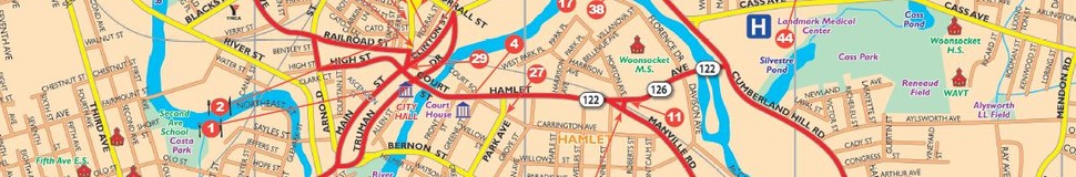
Woonsocket is centrally located in the Boston/Worcester/Providence Triangle, with direct interstate connection to Route 146 and I-295 by way of the newly constructed Route 99. Driving time between Woonsocket and Providence is 15 to 20 minutes. Boston can be reached via I-295 or I-495 to I-95 in about an hour, while travel time to Central Worcester via Route 146 is approximately 40 minutes. State routes 114, 122 and 126 run through the City, providing connections to the Interstate System.
Visit town website: http://www.ci.woonsocket.ri.us/
